
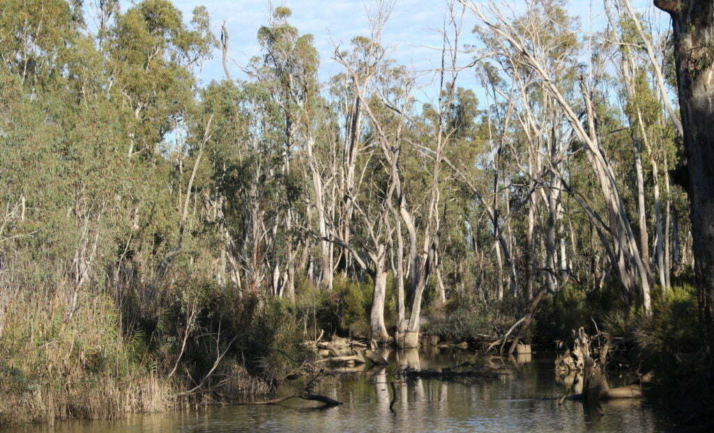
When you think of the conduits for delivering irrigation water, you might conjure up an image of straight cut, steep sided, bare, sometimes plastic-lined channels, adjacent to irrigated farmlands. In contrast to the featured image in northern Victoria, where two major creek systems, the Gunbower Creek and Pyramid Creek, form a major part of the Torrumbarry Irrigation Area delivery system.
These creeks became part of the irrigation system in 1923, with the construction of the Torrumbarry Weir, and since then have been operated just like a channel for the supply of water for irrigation and towns. Under the typical annual irrigation flow regime, water is delivered when there is irrigation demand, and the creeks cease to flow during winter when the irrigation system is shut down. Despite this intensive impact on creek flows, 13 out of the 22 native fish species known to have existed in these creeks are still present today, albeit in very low numbers.
In Victoria, a state-wide method (referred to as the FLOWS method) is used to establish ecological objectives and determine the environmental water flow regime using the natural flow paradigm. Using this approach, environmental water is used recreate the natural range and variability of flows. In Gunbower Creek and Pyramid Creek there are few natural flows. Even in the most recent large floods of 2010 and 2016, there were no unregulated (not ordered) flows through Gunbower Creek, and Pyramid Creek was mostly protected from flooding by upstream storage in Kow Swamp.
Gunbower Creek
The challenge, in such highly-regulated systems, is to deliver environmental flows without impacting on irrigation supply. To achieve this, in Gunbower Creek the delivery of environmental water has used a conceptual model of the Murray Cod life history to develop a full-year hydrograph to drive environmental flow delivery, without compromising irrigation flows. We have targeted Murray Cod, because our monitoring revealed a marked decline in fish numbers, and little evidence of recruitment in the population since the Millennium Drought.
The conceptual model identified the following flow components as being vitally important for Murray Cod – winter flows, spring rise, stable flows, engaging the littoral zone and ramp down.
Of these, the winter flow component was the easiest to achieve as we are the only player in the system during the off-irrigation season, so can achieve this target without impacting on other water users. Irrigation demand and supply generally achieves the spring rise, littoral zone and ramp down flow components.
The stable flow component is the most challenging and to achieve it we used environmental water to raise the water level, filling the gap between irrigation demand and our target flow rate. This enables us to meet our target hydrograph, and to smooth out the overt variation.
Review of past hydrographs from weirs in Gunbower Creek provided examples where, within a few hours, flow rates changed by more than 300 megalitres per day. This situation occurs because of automation in the irrigation system enabling a short turn around time for irrigators to call on water. While good for irrigators, it has come at a cost, with much fluctuation in flow over some regulators. We were concerned that these fluctuations may discourage male Murray Cod from tending their nest around the critical November breeding period.
To combat this overt flow variation, we set our target environmental flow rate quite high, well above the usual irrigation demand, so our flow operators had the flexibility needed to be able to achieve the stable flows. This enabled us to smooth the hydrograph and reduce sub-daily variation.
Pyramid Creek
In Pyramid Creek a similar approach was used to provide flows to stimulate fish movement, particularly Golden and Silver Perch, through the lower Loddon River and the Pyramid Creek system.
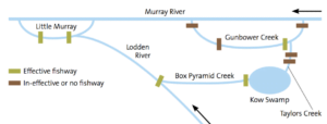
Pyramid Creek was dredged in the 1960s to create a greater channel capacity, destroying all geomorphic variability and turning the creek into a canal. Flows in Pyramid Creek meet the Loddon River at Kerang Weir, where consumptive water is diverted to irrigators via the Kerang Wetlands and conduits flow to the west of the Loddon River. We recognise now that Pyramid Creek is an important conduit between the Loddon River system and the Gunbower Creek system, with the high-value wetalnd habitat Kow Swamp, and important environmental asset connecting these two systems.
We decided to target our flow at two critical components to enable fish to move between the two systems. As with Gunbower Creek, we reintroduced the winter low flow, with the Pyramid Creek FLOWS study also prescribing high flow events to stimulate upstream fish movement from the Murray River.
In April 2017, following the completion of a fish passage structure at Kow Swamp, we delivered an environmental flow through Pyramid Creek and over Kerang Weir during peak irrigation season.
To achieve the flow required to stimulate fish movement, while not compromising consumptive needs, environmental water was delivered with consumptive water to Kerang Weir. To supplement the water that was diverted for irrigation requirements, water was also delivered to meet the flow at Kerang Weir, from the Loddon River. Combining these flows provided the balance between consumptive water in Pyramid Creek, and the flow required downstream of Kerang Weir to encourage fish movement.
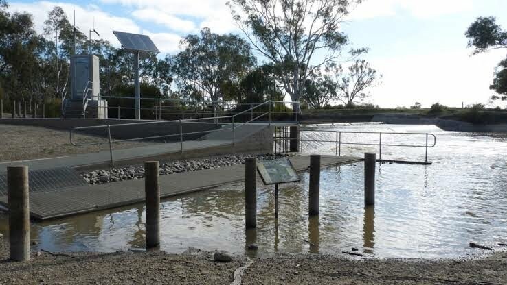
The resulting flow rate at Kerang Weir stimulated the movement of large- and small-bodied native fish species through the fishway at the weir – some moved upstream into the Loddon River, and others through Pyramid Creek using a new fish lock accessing Kow Swamp.
 Our work on Gunbower and Pyramid creeks will be linked as part of the Native Fish Recovery Plan being implemented in northern Victoria. The delivery of environmental flows is only one component of a large breadth of work, identified in the long-term vision of this Plan as being required to improve overall river health and improve conditions for native fish. Other complementary actions are also being implemented, including the installation of fishways to open up historic pathways, reinstating instream woody habitat, and undertaking fencing and revegetation works.
You can download a pdf of the article ‘Fishin’ the creeks‘.


